Trig Points: The Basis for Modern Mapping
Part of the Mapping the Past trail

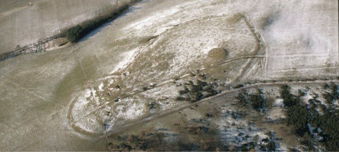
Trig Point at Hill of Kilncadzow
It’s 80 years since Trig Points were first used to Map the Nation. They were designed by Brigadier Martin Hotine to assist in the re-triangulation of Great Britain. The re-triangulation needed fixed points located across the whole country, which could be used to mount survey instruments. From each of these points it was possible to see at least two other Trig Points on a clear day.
Using TRIGonometry, a system of triangles could be established between these points and across the nation. From these triangles accurate measurements of features and buildings could be taken, allowing for more detailed mapping than had been possible before.
6500 Trig Points were erected across the whole of the UK and five survive in and around the Clyde and Avon Valley. These can be found at:
| Trig Point Name | Trig Point Number | OS Grid Reference |
| Blackhill | TP1414 | NS 832 433 |
| Hill of Kilncadzow | TP4206 | NS 888 487 |
| Headshill | TP3699 | NS 715 477 |
| Marshill | TP4676 | NS 784 452 |
| Milton Head | TP4842 | NS 825 495 |
All of these sites are accessible, but both Marshill and Hill of Kincadzow are located in farmland and due care and attention must be taken when visiting. Please follow the Scottish Outdoor Access Code.
Blackhill is a National Trust for Scotland property and is accessible up a rough farm track. Miltonhead is located on Milton Road, to the west of Carluke. There are limited parking spaces, but it is easily accessible. Headshill is located close to the road towards Wellgreen Farm at Heads, just north of Glassford, and is enclosed by fence. Please take care when stopping to view this site.

Map of Trig Points in and around the Clyde and Avon Valley.
This listing was created as part of the Mapping the Past project, managed by Northlight Heritage and delivered by CAVLP Heritage. Explore the site as part of the Mapping the Past trail (see right).


